 |
||||||||
| Floyd, Floyd's Neck,
Bellevue, & Fairfield (unincorporated county)
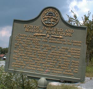
Much of the history of the Floyd area can be found in Camden's Challenge. However, I will cover the basics on this page. (This historical marker disappeared from Hwy. 17 sometime in late 2002 or early 2003.) Floyd's Neck is bordered on the north by the Satilla River, on the south by the Crooked River, on the east by the Cumberland River and marsh, and on the west somewhere between current I95 and Highway 17. Floyd's Neck had a good mix of 60,000 acres marsh and forest. In 1800, Charles Floyd (3/4/1747-9/9/1820), Revolutionary War Sol After Charles Floyd died in 1820, John moved his family into Bellevue. John ran his plantations and generally had between 100-200 slaves. Charles is buried, along with his wife, in the Floyd Family Cemetery. General Charles Rindaldo Floyd, John's son, inherited the lands at Floyd's Neck. His first marriage was to Catherine Powell in 1823. After her death, he married Julia Rose Boog in 1831.
In April of 1999, Midge Mathews (who contributed the sketch and
information for the Pacetti House pages as well as the Brown and Pacetti
gedcoms) invited me to accompany her to the old Floyd cemetery and
plantation property. The gedcoms mentioned above also contain genealogical
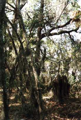
information on the Floyds Midge agreed to let me bring another friend, Jean. Together the 3 of us were ushered through the area in a van driven by Mr. Myers of Rhone Poulanc. The weather was hot but fortunately, where we were (usually under the trees) the temperature was comfortable. The bugs, mosquitoes and gnats, were bad in some areas but for the most part did not bother us too much. On the other hand, ticks were numerous and none of us escaped their clutches! (More on THAT later!)
Our first stop was the Floyd Cemetery. It is listed as "Fairfield" on the
map. Midge explained the relationship between the people in the cemetery. She also told us other information about the folks. Some of this knowledge was commonly known and already published in other formats, while some of the things she told us should not be published. After spending approximately an hour at the cemetery we headed out to visit the old Fairfield plantation site. Nothing is left of the house but there are large concrete and tabby pieces that can still be seen. John Floyd built this home around the same time Bellevue was built. After his death his son, Charles Rinaldo Floyd, inherited the home. He later died at Fairfield and was buried there rather then at the family cemetery. A large marble monument was erected by the US Government in tribute to him. Nestled within a brick enclosure, it's still legible today.
Next on our agenda was a trip to Bellevue, the old home of Charles'
grandfather, also named Charles. When Charles died, his son John moved his
family into Bellevue and made some improvements to the home.
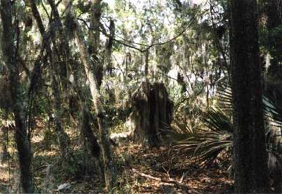
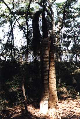
The road that leads to Bellevue was a mile or less. The various owners of this area have tried to some extent to perserve the old tabby home. They have used wood to shore up the walls and keep the area clear of vegetation. Captain Charles Floyd was a seafaring man. True to his early livelyhood he built his home in the shape of a huge, two storied anchor. The upper story was actually made of wood. The only part of the building remaining is the tabby walls (proof of its durability)! Around the walls can still be found bits of pottery as well as rusted door latches, locks, stove parts, etc. The home was very large. Camden's Challenge lists the bottom floor as containing the bedrooms, 3 bathrooms, a dressing room, a kitchen, a dining room, and a game room (in the curved part). The upstairs held a library as well as guest rooms. Challenge also tells of piazzas on two sides with round columns supporting the roof. Charles Rinaldo Floyd died in 1845.
After we left the company of Mr. Myers Midge, Jean, and I drove to a small gas station that had a closed in restaurant area. There we ate our lunch, drank our sweet tea, and picked off our ticks in the comfort of air conditioning! Midge and Jean had the most ticks but I think I get the record for keeping one of them the longest. Nearly a week after the trip I found one stuck behind my knee that had gotten rather fat off of my life- blood! After lunch Jean parted company with us so Midge and I continued wandering the county in her car. She drove to other family homesteads and introduced me to one of her cousins. I really enjoyed the trip and will have to figure out a way to repay Midge for her kindness! Photos taken and copyrighted by M Jean Manning (c1mjm.jpg, c2mjm.jpg, 1mjm.jpg) and Tara D. Fields (bellevuedrawing.jpg, 1tdf.jpg, 2tdf.jpg, b1tdf.jpg, b2tdf.jpg, b3tdf.jpg, b4tdf.jpg, b5tdf.jpg) all 1999-2001.
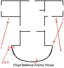
I created this simple drawing based on information from Camden's Challenge as well as from my own memory. The front walls of the round room have collapsed. Wood beams are bracing the sidewalls of the round room. The spaces indicate doorways. Rubble from the collapsed walls litter the area - of which the majority covers the ground in the round room (a.k.a. "game room"). The numbers and lines indicate approximately the angle each picture was taken from. Please use your browser's "Back Button" to return to this page after viewing a thumbnail.
|
||||||||
 dier,
moved his family down to his land at Floyd's Neck, Camden County. Charles
was the son of Samuel & Sarah Dixon Floyd. Charles was married to Mary
Fendin (4/10/1747-9/18/1804) in 1768. Mary was the daughter of John and
Elizabeth Thomas Fendin. They had one son, John. John was married to
Isabella Maria Hazzard (10/3/1769-6/24/1839). Isabella was the daughter of
Richard and Phoebe Loftain Hazzard. John and Isabella eventually had 12
children! In 1804, John built a house for himself, Fairfield, and one for
his father, named Bellevue. John later served in the war of 1812 and
fought against the Indians. During the War of 1812, a British scouting
party burned down Fairfield while John, and his family, was away helping
defend Savannah. Luckily, a caretaker was able to put out the flames.
dier,
moved his family down to his land at Floyd's Neck, Camden County. Charles
was the son of Samuel & Sarah Dixon Floyd. Charles was married to Mary
Fendin (4/10/1747-9/18/1804) in 1768. Mary was the daughter of John and
Elizabeth Thomas Fendin. They had one son, John. John was married to
Isabella Maria Hazzard (10/3/1769-6/24/1839). Isabella was the daughter of
Richard and Phoebe Loftain Hazzard. John and Isabella eventually had 12
children! In 1804, John built a house for himself, Fairfield, and one for
his father, named Bellevue. John later served in the war of 1812 and
fought against the Indians. During the War of 1812, a British scouting
party burned down Fairfield while John, and his family, was away helping
defend Savannah. Luckily, a caretaker was able to put out the flames.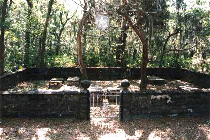 After
helping drive the Indians out of the Okefenokee Swamp, C. R. Floyd had one
of the islands named after him. The name remains to this day. His
grandfather, Charles, had a Georgia county named after him - Floyd County.
Eventually the land fell into the hands of other businesses and settlers.
See C. T. Trowell's GENERAL CHARLES R. FLOYD AND THE SECOND SEMINOLE WAR
IN THE OKEFENOKEE SWAMP.
After
helping drive the Indians out of the Okefenokee Swamp, C. R. Floyd had one
of the islands named after him. The name remains to this day. His
grandfather, Charles, had a Georgia county named after him - Floyd County.
Eventually the land fell into the hands of other businesses and settlers.
See C. T. Trowell's GENERAL CHARLES R. FLOYD AND THE SECOND SEMINOLE WAR
IN THE OKEFENOKEE SWAMP.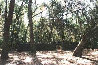 which I have used excerpts from. Located on Union Camp land, Midge had to
get permission from Rhone Poulanc to go through the area. I was honored to
go out there and get the grand tour from a descendent. She was also kind
enough to postpone the trip for a short while because I had to go out of
town and did not want to miss it!
which I have used excerpts from. Located on Union Camp land, Midge had to
get permission from Rhone Poulanc to go through the area. I was honored to
go out there and get the grand tour from a descendent. She was also kind
enough to postpone the trip for a short while because I had to go out of
town and did not want to miss it!
 Our
excursion took an exciting (if that is a good word for it!) turn when we
became stuck in the sand! The van was large and obviously very heavy. It had
not rained for quite some time and in fact, we were in a sort of a drought.
The roads had become very sandy. After much fussing attempting to dig and
wedge the van out of the sand, Mr. Myers called a co-worker for some aid.
Luckily, there were some workers with heavy machinery nearby. They hooked up
to the van and pulled us right out. We were on our way again!
Our
excursion took an exciting (if that is a good word for it!) turn when we
became stuck in the sand! The van was large and obviously very heavy. It had
not rained for quite some time and in fact, we were in a sort of a drought.
The roads had become very sandy. After much fussing attempting to dig and
wedge the van out of the sand, Mr. Myers called a co-worker for some aid.
Luckily, there were some workers with heavy machinery nearby. They hooked up
to the van and pulled us right out. We were on our way again!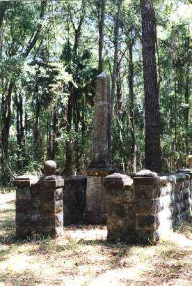 Fairfield was the name of the plantation but the cemetery just goes by the
name "Floyd." We spent some time out there reading the graves and taking
as many photos as we could. Jean even climbed a tree to get up high enough
to take a good shot of the cemetery over the walls! I attempted to take a
picture of her coming down the tree but my film did not develop properly!
Ah well…
Fairfield was the name of the plantation but the cemetery just goes by the
name "Floyd." We spent some time out there reading the graves and taking
as many photos as we could. Jean even climbed a tree to get up high enough
to take a good shot of the cemetery over the walls! I attempted to take a
picture of her coming down the tree but my film did not develop properly!
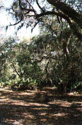
Ah well…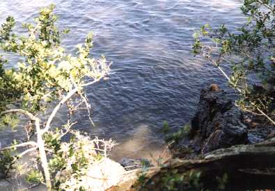 Fairfield
is just a short distance from the Satilla River. I walked a short ways
through the woods and took some photos of the river and marsh. It's very
quiet and peaceful in this area. The only intrusion to the peace was our
own van and one motorboat on the river.
Fairfield
is just a short distance from the Satilla River. I walked a short ways
through the woods and took some photos of the river and marsh. It's very
quiet and peaceful in this area. The only intrusion to the peace was our
own van and one motorboat on the river.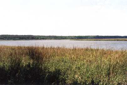
 Eventually,
the land of Floyd's Neck was divided among various families and companies.
Today all that remains of the Floyd plantations are some of the trees they
planted, the old family cemetery, and the ruins of Bellevue.
Eventually,
the land of Floyd's Neck was divided among various families and companies.
Today all that remains of the Floyd plantations are some of the trees they
planted, the old family cemetery, and the ruins of Bellevue.